Introduction
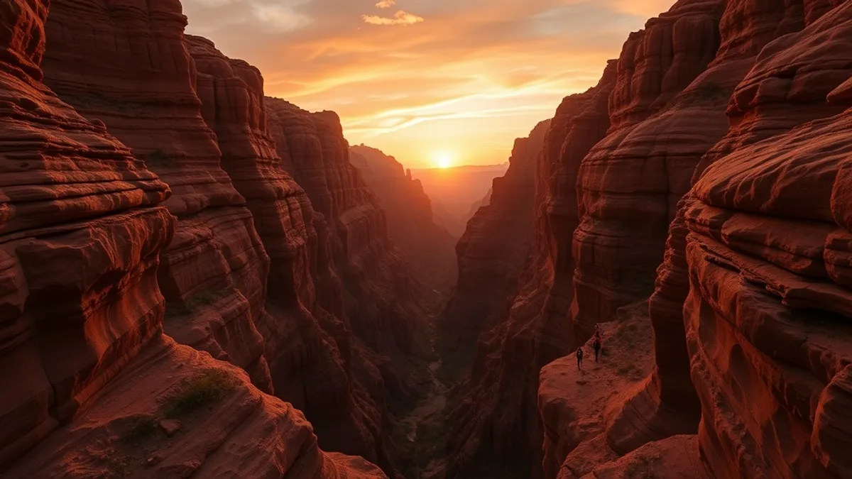
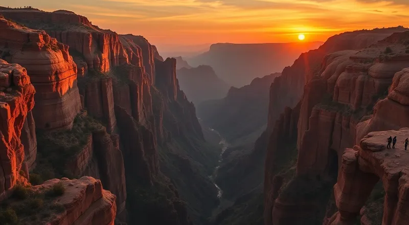
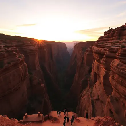
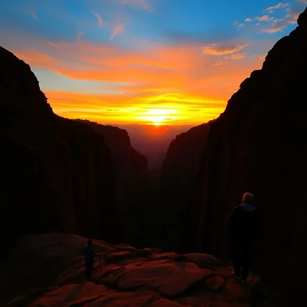
Eight kilometres south of Pai's centre, the valley floor fractures into a geological surprise that stops every first-time visitor in their tracks. Pai Canyon — known locally as Kong Lan — is a formation of narrow sandstone ridges rising from the valley floor with drops of up to 30 metres on either side, separated by paths so narrow that two people cannot comfortably pass without pausing and pressing to one side. The canyon was carved over millennia by seasonal water erosion into the soft red and orange sandstone, producing a labyrinthine terrain of knife-edge ridges, blind curves, and sudden open platforms from which the full sweep of the Pai valley becomes visible in a panorama framed by layered mountain ridges. At sunset, the transformation is complete: the sandstone turns the colour of embers, the mountains deepen to purple, and the sky above fills with a theatrical gradient of orange, pink, and fading blue that makes every photograph taken here feel slightly implausible. Pai Canyon is one of northern Thailand's most arresting natural spectacles, and it costs nothing to enter.
Overview
Pai Canyon sits alongside a handful of other viewpoints that collectively make the area south and east of Pai town one of the most rewarding scenic circuits in northern Thailand. The combination of the canyon itself, the Yun Lai sunrise viewpoint, the Pai Memorial Bridge over its rice paddy landscape, and the general visual abundance of the valley floor creates a half-day or full-day itinerary that no amount of café-sitting and Walking Street browsing should crowd out of a Pai visit.
The canyon trail begins at a small car park off Highway 1095 approximately 8 kilometres south of Pai, marked by a sign and a line of food stalls and souvenir vendors that gather in the late afternoon before sunset. The trail onto the ridges requires no technical skill but demands genuine attention — the edges are unguarded, the sandstone is sometimes loose underfoot, and the drops on either side of the narrowest sections are serious. Sandals with good grip or closed-toed shoes with rubber soles are the correct footwear. The main circuit of the ridges takes approximately 45 minutes to one hour at a moderate pace; more adventurous walkers can extend this by following smaller trails into the secondary canyon areas on the eastern side of the formation where the crowds thin to almost nothing. Sunrise visits are quieter than sunset and produce different lighting — the morning mist that fills the valley below the ridges in December and January adds a dimension that no sunset visit can replicate.
Yun Lai Viewpoint, located approximately 30 minutes drive west of Pai town on a small road climbing into the hills above the Santichon Chinese Village area, is the preferred sunrise destination for those who want a broader landscape perspective rather than the canyon's more intimate drama. The viewpoint looks east across the whole Pai valley from an elevation of approximately 1,100 metres, and on clear mornings in November to January, a sea of white cloud fills the valley below while the mountain ridges on the far side emerge as dark blue silhouettes against a sky that begins to colour from around 5:45 AM. The road to Yun Lai requires a motorbike or vehicle — it is too long and steep to walk before dawn — and the turn-off from the main road is small and easy to miss in the dark. Most Pai guesthouses can provide precise directions.
The Pai Memorial Bridge (also known as the World War II Memorial Bridge or the Japanese Bridge) spans the Mae Nam Pai approximately 4 kilometres northwest of town and is best experienced in the morning when the surrounding rice paddies catch the low light and the bridge's wooden structure glows against the green of the fields. The bridge was originally constructed by Japanese forces during their Second World War occupation of the region and rebuilt several times since, most recently in bamboo and wood. It is not a dramatic structure in itself but the approach road and the surrounding agricultural landscape — particularly in the rice-growing season from July to October — compose into a pastoral scene of considerable beauty. The view from the bridge looking south toward the distant mountain ridge is one of the most photographed compositions in northern Thailand.

Highlights
- Pai Canyon (Kong Lan) at sunset — narrow sandstone ridges with 30m drops, dramatic orange-red colouring in the evening light
- Canyon sunrise alternative — misty valley views below the ridges in December-January with dramatically fewer visitors
- Yun Lai Viewpoint — sea of cloud over the full Pai valley at sunrise from 1,100m elevation, 30 min from town
- Pai Memorial Bridge (WWII Japanese Bridge) — bamboo and wood bridge over rice paddies with pastoral mountain backdrop
- Secondary canyon trails — quieter eastern sections of Kong Lan with the same dramatic terrain and no crowds
- Sunset food stalls at the canyon car park — grilled corn, coconut drinks, and local snacks while watching the light change
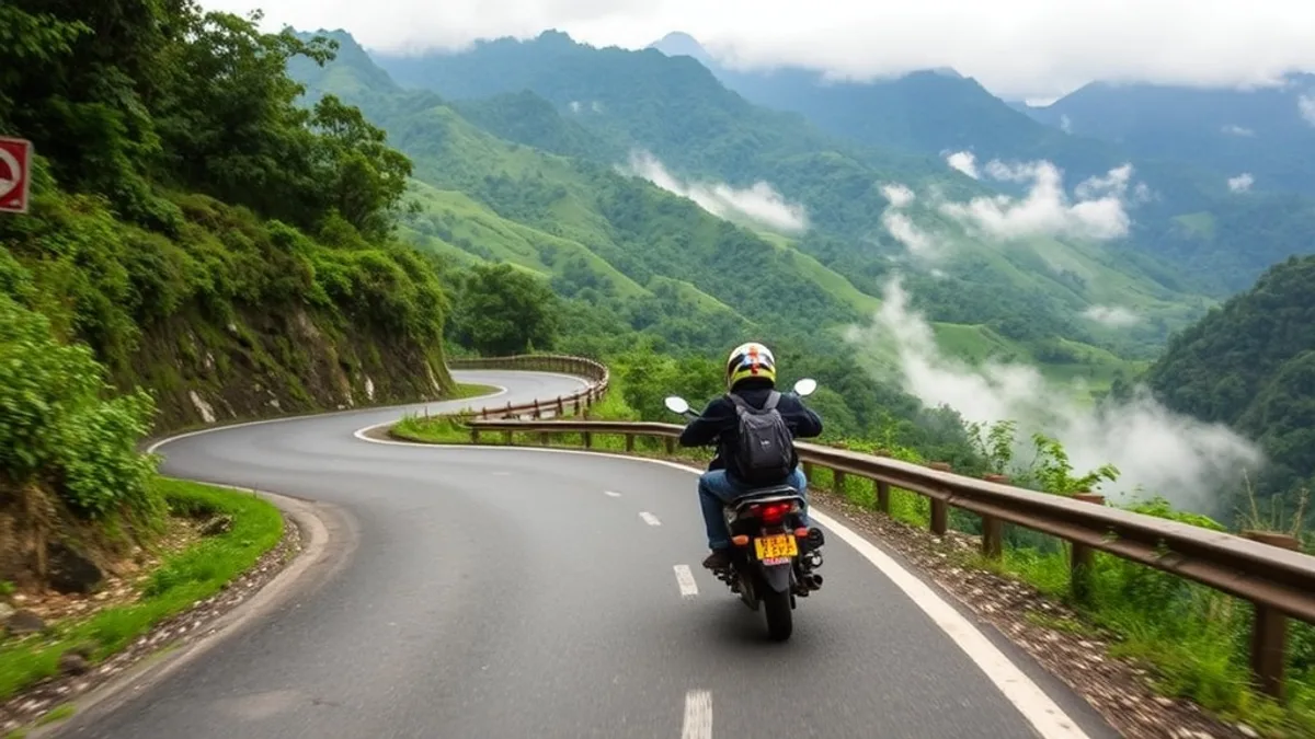
- Full viewpoint motorbike loop — canyon + Yun Lai + Memorial Bridge + rice paddies in a single half-day circuit
- Canyon edge photography — knife-edge ridges producing technically challenging and visually dramatic photographic compositions
- Valley floor patchwork — rice fields, river curves, and village rooftops visible from the canyon rim as a complete landscape
October to February is the optimal period for all Pai viewpoints. Pai Canyon is most dramatic at sunset from November to January when the sandstone's warm tones are matched by an equally vivid sky. Yun Lai Viewpoint sunrise is most rewarding from November to February when cool temperatures produce the valley mist that makes the sea-of-cloud effect possible. The Memorial Bridge is most photogenic during and immediately after the rice-growing season (July-November) when the surrounding paddies are bright green or golden. The rainy season (June to September) covers the valley in a lush, dramatic greenness but cloud cover often obscures the distant mountain ridges and sunrise viewpoints.
Practical Information
Cost Level
Pai Canyon entry is free — no ticket, no park fee. Yun Lai Viewpoint may charge a small entry fee (20-50 THB) depending on the landowner arrangements in season. The Pai Memorial Bridge area is free. The primary cost for this circuit is motorbike rental at 200-400 THB per day. Sunset at the canyon attracts food vendors where a meal of grilled items and drinks costs 80-150 THB. The full viewpoint circuit can be completed for 300-500 THB total including motorbike fuel and any food. Guided viewpoint tours from Pai town operators cost approximately 500-800 THB per person including motorbike.
Tips
Wear grip-soled footwear at Pai Canyon — flip flops and smooth-soled sandals are genuinely dangerous on the loose sandstone ridge edges. Arrive at the canyon 30-40 minutes before sunset to walk the ridges in the clear afternoon light before the colours intensify; last-minute arrivals miss the experience of the ridges themselves and only catch the view. For Yun Lai sunrise, set your alarm for 5 AM and ride slowly on the mountain road in the pre-dawn darkness — motorbike headlights are sometimes insufficient on unfamiliar roads. Carry a torch on the canyon if arriving close to dusk, as the return trail becomes difficult in low light. Drones are restricted around the canyon area — check current regulations before flying.
Our creators on the ground in Pai share their best recommendations in their videos.
Creators who cover this spot
Discover YouTube creators who feature this topic in their videos.
Adventures Joel
British adventure vlogger exploring Thailand by motorbike.
Global Travel Mate
Jeroen is a Dutch expat documenting Bangkok's urban landscape through bicycle exploration and cultural observation.
travelventure
Marie & Jan
travelventure – Groesster deutschsprachiger Reise-Creator auf YouTube.
Places in this Guide
Discover the attractions and locations featured in this travel guide.
Explore Pai
Pai
ปายPai is a laid-back mountain village tucked away in the valleys of Mae Hong Son province, beloved for its bohemian atmosp...All creators from Pai →Location & Orientation
Frequently Asked Questions
Is Pai Canyon dangerous and what should I wear?
Pai Canyon is a real natural hazard — the ridge paths are narrow, the sandstone is sometimes loose or crumbly, and the drops on either side of the main spine reach 30 metres with no safety barriers. Each year a small number of visitors are injured, most commonly by losing footing on loose sections. The risks are manageable with appropriate footwear (closed-toed shoes or sandals with rubber grip soles, not flip flops), staying on established paths, avoiding canyon visits after rain when the sandstone becomes slippery, and not attempting the narrowest sections after dark. Children should be held by hand on all sections of the ridge trail. The canyon is not technically difficult — it requires attention and respect rather than any special skill.
What time should I arrive at Pai Canyon for sunset?
Arrive 45 minutes to one hour before sunset to make the most of the canyon visit. This gives you time to walk the full ridge circuit in good afternoon light, find your preferred position on the ridge for sunset, and experience both the canyon's geometry and the light transition. Sunset times in Pai vary seasonally: approximately 6:15 PM in November, 5:55 PM in December and January, 6:15 PM in February, and up to 6:45 PM in the March-April period. Check the exact date's sunset time on any weather app and subtract one hour to establish your arrival time. The car park and food stalls fill up from about 30 minutes before sunset — arriving earlier means a less crowded ridge walk.
Can I visit both Yun Lai Viewpoint and Pai Canyon in the same day?
Yes — combining sunrise at Yun Lai with sunset at Pai Canyon is one of Pai's signature full-day experiences and is easily managed with a motorbike. Wake up at 5 AM, ride to Yun Lai (30 min) for sunrise, return to Pai for breakfast, spend the day exploring the town or hot springs, then ride south to the canyon (15 min) for sunset. The total driving time is minimal and the contrast between the wide, misty valley panorama of Yun Lai and the intimate geological drama of Kong Lan makes the two viewpoints complementary rather than redundant. Add the Memorial Bridge as a morning stop between Yun Lai and breakfast for a complete northern Pai loop.
Where exactly is Yun Lai Viewpoint and how do I get there?
Yun Lai Viewpoint sits in the hills above Santichon Chinese Village, approximately 6 kilometres west-northwest of Pai town centre. Take the main road west from town toward Santichon, pass through or past the village, and continue on the road as it climbs into the hills. The viewpoint is marked by a gate with a small entrance area; the final approach road is narrow and steep. Navigation by Google Maps works reliably — search 'Yun Lai Viewpoint Pai' for the pin. The road requires a motorbike or small car; larger vehicles cannot navigate the final section. For a sunrise visit, depart Pai no later than 5:30 AM to allow time for the approach road in darkness.
Is the Pai Memorial Bridge the same as the bamboo bridge over the rice paddies?
The names are sometimes confused. The Pai Memorial Bridge (also called the World War II Bridge or Japanese Bridge) is a fixed structure approximately 4 kilometres northwest of town, built on the site of a Second World War Japanese military bridge over the Mae Nam Pai. It spans the river and is surrounded by rice paddy fields. The bamboo bridge is a separate, seasonal structure on the eastern side of town, near Wat Pa Kham temple, that leads across rice paddies to a small art community — this bridge is rebuilt each year after the rains and is primarily a village and artistic landmark rather than a historical one. Both are worth visiting but they are different structures in different locations.