Introduction
Most visitors to Hat Yai never consider that within an hour's drive of the city's market streets and fried chicken stalls lies some of the most ecologically significant and scenically dramatic landscape in peninsular Thailand. The Ton Nga Chang Wildlife Sanctuary, anchored by the spectacular seven-tiered waterfall that gives it its name — Ton Nga Chang means 'elephant tusk', describing the shape of the uppermost fall — protects a substantial fragment of the lowland rainforest that once blanketed the entire Thai-Malay Peninsula. Gibbons call from the canopy, hornbills navigate the forest edge, and if you are patient and quiet on the sanctuary trails at dawn or dusk, wild elephants move through the deeper forest. This is Hat Yai's best-kept secret, maintained in near-obscurity by the city's overwhelming reputation as a food and shopping destination. Adding a half-day or full-day nature excursion to any Hat Yai visit transforms the trip from a purely urban experience into something far more dimensional.
Overview
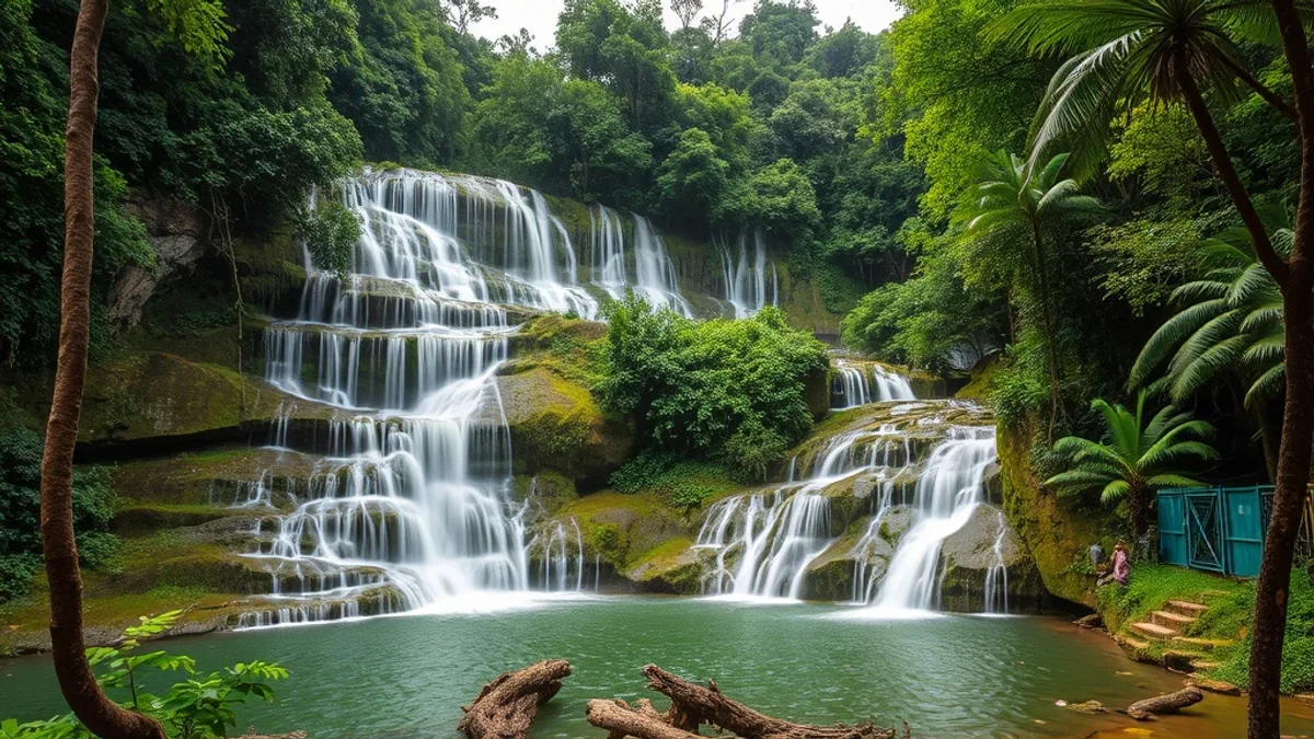
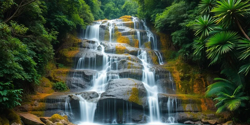
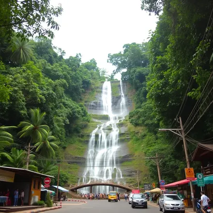
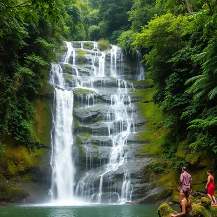
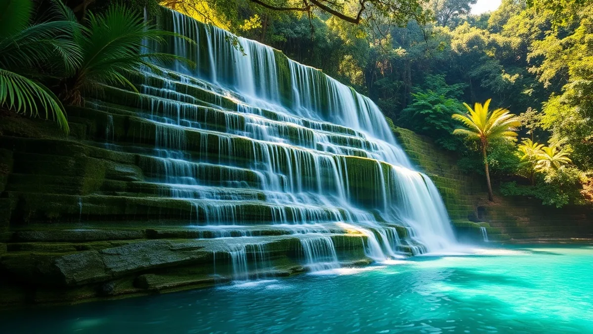
The Ton Nga Chang Waterfall is the centrepiece of the wildlife sanctuary bearing the same name. The waterfall descends in seven distinct tiers through a landscape of granite boulders, tropical ferns, and dense forest canopy, with each tier offering a different character — the upper tiers are dramatic and high, the lower tiers more accessible with natural pools suitable for swimming during the rainy and early dry seasons. The name references the shape of the highest visible fall, where two streams split around a central rock formation before reuniting, creating a silhouette that local people historically interpreted as the tusks of an elephant. The waterfall is approximately 60 to 70 kilometres from Hat Yai city centre — realistically one hour by car or songthaew (shared truck taxi). Independent travel by rented motorbike is possible and popular, though the road requires reasonable riding experience. Admission to the sanctuary is nominal at 20 to 40 THB for Thai nationals, slightly higher for foreign visitors.
The wildlife sanctuary that surrounds the waterfall is one of the more important protected forest fragments in lower peninsular Thailand. The forest type here is lowland tropical rainforest, structurally complex and biologically rich in a way that more accessible or more heavily visited sites typically are not. White-handed gibbons are regularly heard and sometimes seen from the main trails — their distinctive territorial calls, carrying over long distances at dawn and dusk, are among the most evocative sounds in Southeast Asian nature. Multiple hornbill species, including the Great Hornbill and the Oriental Pied Hornbill, are present and visible to birders and patient general visitors willing to spend time at forest edges during early morning hours. Wild Asian elephants use the forest, though encounters are more likely in the deeper interior sections accessible only with a guide than on the main waterfall trail. The sanctuary's ranger station offers guided wildlife walks for groups; these should be arranged in advance through the sanctuary office or through Hat Yai tour operators.
Khao Nam Khang National Park, approximately 80 kilometres from Hat Yai in Rattaphum District, offers one of southern Thailand's most historically unusual attractions alongside its natural appeal. The park encompasses a system of tunnels used by the Communist Party of Malaya and affiliated Thai insurgents during a decades-long guerrilla campaign that continued in isolated areas well into the 1980s. The tunnels, now open to visitors on guided tours, include a combination of natural limestone caves and human-excavated passages that served as command centres, weapons caches, and living quarters. The park ranger station leads tours through the accessible tunnel sections, and interpretive materials provide historical context for the insurgency and its resolution. The surrounding park landscape is spectacular limestone karst scenery with forest trails, caves, and viewpoints that justify the visit independent of the historical dimension.
The Klong Hoi Khong area, accessible on the road between Hat Yai and the coast, offers mangrove forest exploration as a contrast to the inland rainforest experience. Longtail boat tours navigate through mangrove channels where monitor lizards, kingfishers, and various wading bird species are commonly observed. The tidal cycles strongly influence wildlife viewing — early morning or late afternoon tours at incoming tide are recommended. Bang Klam, a small district northeast of Hat Yai city, has developed a modest eco-tourism infrastructure around its remnant natural areas, with local guides available for village-level nature walks that provide a more community-integrated experience than the larger national park sites.
Highlights
- Ton Nga Chang Waterfall — seven-tiered waterfall in protected wildlife sanctuary, 60km from Hat Yai, natural swimming pools at lower tiers
- Ton Nga Chang Wildlife Sanctuary — intact lowland rainforest, white-handed gibbons, multiple hornbill species, wild Asian elephants in deeper zones
- Khao Nam Khang National Park — unique Communist guerrilla tunnel system from the 20th-century insurgency, now open for guided tours alongside spectacular karst scenery
- Dawn gibbon calls — one of Southeast Asia's most evocative wildlife experiences, audible from trails near the waterfall at first light
- Great Hornbill sightings — one of Asia's most spectacular birds, reliably present at Ton Nga Chang for patient early-morning observers
- Wild elephant tracking — guided ranger walks into deeper sanctuary areas for elephant sign and occasional sightings
- Klong Hoi Khong mangrove boat tours — longtail boat navigation through mangrove channels, monitor lizards, kingfishers, wading birds
- Khao Nam Khang limestone karst viewpoints — dramatic geological scenery independent of the historical tunnel tours
- Rattaphum District eco-tourism — community-based village walks and local guide encounters providing authentic rural southern Thai experience
- Motorbike self-drive route from Hat Yai — scenic roads through rubber plantations and rice fields linking the natural sites, suitable for experienced riders
The waterfall and surrounding forest are most spectacular from September through January — the rainy season replenishes the waterfall's flow, and the early cool season months see the forest at its most verdant with the highest wildlife activity. From February through May, water levels drop and the upper tiers can reduce to a trickle during the late dry season. Wildlife watching is best in the early morning throughout the year — arrive at the waterfall car park before 7am and spend the first hour on the lower forest trails for the best chance of gibbon calls and hornbill activity. Khao Nam Khang tunnel tours operate throughout the year but are more comfortable in the cool season months.
Practical Information
Cost Level
Day trips from Hat Yai to Ton Nga Chang Waterfall cost approximately 600-900 THB per person through Hat Yai tour operators, including transport and a guide. Self-drive by rented motorbike costs 200-300 THB for petrol and road tolls plus 100-200 THB motorbike rental per day. Sanctuary entrance fees are 40-80 THB. Guided wildlife walks within the sanctuary cost 200-400 THB per person when arranged through the ranger station. Khao Nam Khang tunnel tours cost 100-200 THB per person including guide. Klong Hoi Khong mangrove boat tours run 200-400 THB per person for a one-hour tour. Overall, a full day of nature excursions from Hat Yai is achievable for 800-1,500 THB including transport and all entrance fees.
Tips
Book guided wildlife walks at Ton Nga Chang through your Hat Yai hotel or a local tour operator at least one day in advance — the sanctuary ranger station has limited English-language capacity and advance notice improves the quality of the experience significantly. Bring insect repellent appropriate for tropical forest use — the forest is beautiful but the insects are abundant. For the Khao Nam Khang tunnel tour, wear shoes (not sandals) that you are comfortable getting muddy, and bring a torch even if the ranger provides one, as the backup light source is reassuring in the tighter tunnel sections. For self-drive motorbike excursions, check the weather forecast — the road to Ton Nga Chang has some unpaved sections that become significantly more demanding in heavy rain.
Our creators on the ground in Hat-yai share their best recommendations in their videos.
Creators who cover this spot
Discover YouTube creators who feature this topic in their videos.
Adventures Joel
British adventure vlogger exploring Thailand by motorbike.
Global Travel Mate
Jeroen is a Dutch expat documenting Bangkok's urban landscape through bicycle exploration and cultural observation.
travelventure
Marie & Jan
travelventure – Groesster deutschsprachiger Reise-Creator auf YouTube.

Places in this Guide
Discover the attractions and locations featured in this travel guide.
Explore Hat Yai
Hat Yai
หาดใหญ่Hat Yai is the largest city in southern Thailand and a bustling commercial hub known for its incredible street food, liv...All creators from Hat Yai →Location & Orientation

Frequently Asked Questions
How do I get to Ton Nga Chang Waterfall from Hat Yai city centre?
The most comfortable option for independent travellers is to hire a songthaew (shared pickup truck taxi) from Hat Yai's main transport terminal — negotiate a charter rate of approximately 500-700 THB for a return trip with waiting time. Alternatively, Hat Yai tour operators offer half-day waterfall excursions at 600-900 THB per person including guide. Renting a motorbike from Hat Yai (200-300 THB per day) and self-driving is popular among experienced riders — the route follows Highway 4 west of Hat Yai before turning north into the sanctuary, taking approximately one hour. Grab and local taxis can drop you at the waterfall but will not wait for a return trip without advance arrangement. There is no regular scheduled public transport to the sanctuary.
What are the Communist guerrilla tunnels at Khao Nam Khang National Park?
The tunnel system at Khao Nam Khang National Park was constructed and used by the Communist Party of Malaya (CPM) and its affiliated organisations during a prolonged insurgency that began in Malaya in 1948 and continued in isolated border areas of southern Thailand through the 1970s and into the 1980s. The tunnels served as command posts, supply routes, and living quarters for insurgents who used the remote limestone hills of southern Thailand as a base area adjacent to the Malaysian border. The CPM formally abandoned armed struggle in 1989, and the tunnel system was subsequently opened for tourism by the Royal Thai Forestry Department. Guided tours last approximately one to two hours and combine historical interpretation with exploration of the tunnel passages. The site offers a genuinely unusual window into a largely forgotten chapter of Cold War-era Southeast Asian history.
Is it possible to see wild elephants near Hat Yai?
Wild Asian elephants are present within the Ton Nga Chang Wildlife Sanctuary and adjacent forest areas, though sightings are neither guaranteed nor predictable for visitors on standard waterfall excursions. The animals inhabit the deeper forest interior and follow seasonal patterns influenced by food and water availability. The best opportunities for elephant encounters come through guided ranger walks into sections of the sanctuary away from the main waterfall trail, typically lasting three to four hours and requiring advance booking. Rangers familiar with current elephant movement patterns have the best understanding of likely encounter zones. Even without a sighting, fresh elephant sign — tracks, dung, and vegetation disturbance — is commonly found and provides evidence of the population's active presence in the forest.
What wildlife can I realistically expect to see at Ton Nga Chang?
Realistic wildlife expectations for a morning visit to Ton Nga Chang depend on timing and patience. White-handed gibbon calls are heard on most early morning visits (before 8am) and the animals are occasionally visible in the canopy above the main trail. Oriental Pied Hornbills are regularly seen flying over the forest edge; Great Hornbills require more patience and forest-edge observation but are present in the sanctuary. Macaques (Long-tailed Macaques) are commonly seen near the car park and lower trail area. Monitor lizards are abundant near the waterfall pools. Butterflies in extraordinary variety are present throughout the year. Birds are diverse and reward birders with a field guide — kingfishers, woodpeckers, pittas (seasonal), and various sunbird species are all recorded. Wild boar sign is common; sightings are less predictable. Wild elephants remain a possibility rather than an expectation on day visits.
Can I swim at Ton Nga Chang Waterfall?
Swimming is possible at the lower tiers of Ton Nga Chang Waterfall during the rainy season (May through January) when water levels are high enough to create natural pools of sufficient depth. The best swimming conditions are typically from September through November at the peak of the rainy season, when water flow is strongest and the pools are deepest and clearest. From February through April, water levels typically drop significantly and the lower tier pools may become too shallow for comfortable swimming. The water temperature is refreshing rather than cold — the streams are fed by tropical rainfall rather than snowmelt — and swimming conditions are safe except immediately after heavy rainfall, when flash flooding risk increases in the narrower gorge sections. During swimming, be aware of slippery rocks and current in the gorge sections above the main pools.